![]() Contact us by phone: 561 450-8258. Contact us by email.
Contact us by phone: 561 450-8258. Contact us by email.
Hurricane Irene heading our way?
By Palm Beach Business.com
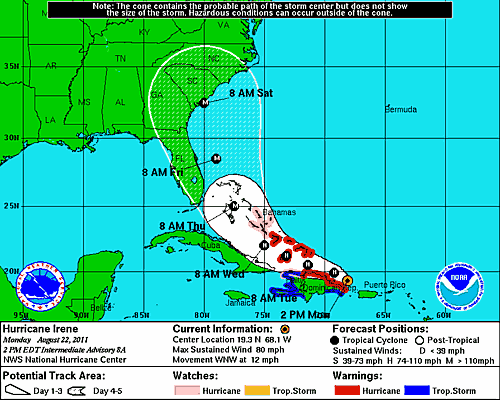
DELRAY BEACH — Hurricane Irene is gaining strength, and is expected to reach category 3 strength when it reachs our backyard on Thursday. That's the bad news.
The good news is that the National Hurricane Center has shifted the forecast path of the storm further to the east, making it less likely that Florida will be hit by tropical storm-force winds, let alone a hurricane.
However, all of Florida's east coast remains within the cone of error.
The National Hurricane Center is projecting that Irene will track through the Bahamas and move up the Florida coast throughout the week. Warnings and watches have been issued for the Bahamas, but not for Florida.
 As of 2 p.m., the National Hurricane Center had Irene a category 1 storm with 80 mph winds off the Dominican Republic. It was moving in a general northwestern direction.
As of 8 p.m., the National Hurricane Center said Irene had sustained winds of 100 mph, making it a category 2 storm. The center is projecting Irene to be a category 3 storm by Thursday, with winds at 130 mph, and gusts up to 160 mph.
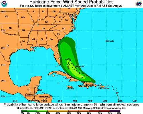
At this point, however, chances are minimal that hurricane-force winds will hit the mainland — about 5 percent according to the NHC. Chances of tropical storm-force winds — between 35 and 74 mph — are about 40 percent.